Loading rainfall or flow rate from external sources
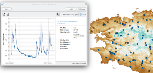
Now, Lekan allows the user to load some data from external sources. The infrastructure is ready to host any flow or rainfall data providers. For now, two data providers are proposed:
– Delft-FEWS XML files: files created by the Delft-FEWS software that can contain rainfall or flow data
– Hubeau server: a remote server that provides real-time flow data of French rivers. As this provider concern only French territory, it is not implemented by default. Any user interested can contact me to
We could add more providers, so don’t hesitate to contact or fill a ticket here if you want to add a specific data provider.


Rainfall stations are now spatial
With version 2.2, rainfall stations can be geolocalized with a point on the map. Once the rainfall manager opens, each geolocalized rainfall station is associated with a marker on the map canvas.
The user can geolocalize a station by picking its position on the map or loading rainfall data from a file containing spatial information.
Associate gauged hydrographs with watershed
Any watershed delineated with Lekan can be associated with “gauged” hydrographs. Here, gauged hydrograph is simply a flow rate time series with variable time steps. It can come from real flow measurement or any source providing a flow rate time series.
To define a gauged hydrograph, users can either fill a table manually or copy/paste or import a hydrograph from an external source.
Once associated, hydrographs can be plotted with the runoff hydrograph calculation for comparison, or they can also be injected into the hydraulic network (see below).
Hydraulic Network
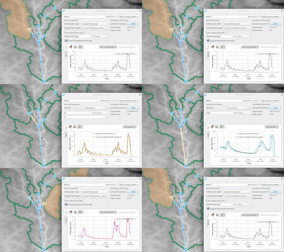
This version of Lekan introduces new capabilities for hydrological/hydraulic analysis. Indeed, now, the user can define a network to simulate flow propagation. The principle of the hydraulic network is a set of elements relied on each other.
This first version of the Hydraulique Network module has the following elements available:
– node junction summing hydrographs coming from upstream links and eventually a gauged hydrograph associated with the node
– watershed node, a junction node associated with a delineated watershed that sums upstreams hydrographs and a calculated runoff hydrograph or a gauged one.
– routing links that simulate the propagation of a hydrograph between two nodes considering a routing method.

These elements are pretty simple and allow only basic simulation of flow propagation. However, this new Hydraulic Network module opens new possibilities. In the future, new functionalities will help the user to study flow propagation in a hydraulic network (natural or anthropogenic). From now, we can imagine all sorts of nodes or links: hydraulic structure, retention basin or retention dam, even hydraulic models linked each other,…

Plots
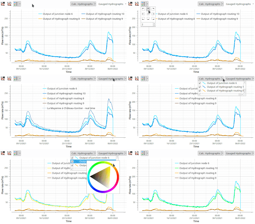
Plot displaying has been improved, with the possibility to customize the legend, to activate/deactivate curves and to change their color.
What next ?
This version marks an essential milestone in the development of Lekan.
The addition of the Hydraulic Network module will extend the hydraulic analysis with many other tools.
The next step is to add the possibility of editing 2D hydraulic mesh model structures as generically as possible. The objective will be to create models directly from Lekan, launch the calculations from Lekan with some external modeling engines, and visualize the results via the mesh layers integrated into Lekan through the QGIS API.
It is the next direction of development, but a lot of other features could be added to help the user hydraulic studies.
If the imagination is the only limit to what can be done, it takes time. My aim in the development of Lekan is to make the tool I would have liked to have in my former life as a hydraulic engineer. And in the spirit of the Open Source (not only free but with all sharable, even the code).
But it also takes time to live and earn what is necessary to do it.
So if you like this software and/or what it could become, help is very welcome. Indeed, the effort of only one guy on a tiny island somewhere in Caribbean could not be enough, even with the participation of translators in 5 different languages (thanks to them!!!).
So, if you want to help, take a look at this page.

Hello, and thankyou for your work with lekan software.
I just would like to ask you if in Lekan 2.2. is possible upload watershed delineated in QGIS environment and make hydrological/hydraulic analysis for this?
I can load the watershed outlined in QGIS in Lekan but I cannot calculate the hydrological / hydraulic characteristics.
Regards, Fabio
Hello,
No, unfortunately, you can’t with v. 2.2.
But the idea to be able to choose an existing polygon from a vector layer to add a watershed is in mind (see https://github.com/vcloarec/ReosProject/issues/14).
It is now available in the experimental version 2.2.9X.
I use a totally free and open source, extremely stable and powerful full 2D solver, with shock capturing, and ability to use grid rain directly over the entire catchment mesh domain. The model is called ANUGA Hydro, it uses a flexibly sized triangular mesh, and usually polygons control the spatial variation in cell size. However your mesher tools potentially provide more flexibility? It seems Lekan may be a very good platform to build and control the Python ANUGA run Scripts ?
I’ve started months ago to use this software and I think it has a great potential in hydraulic and hydrological analysis. I would just suggest to insert, in the code, a numerical control to avoid, in resulting flow values, very small numbers (such as 1E-300). This occurs for ietographs containing long dry periods (f.e. an annual rain record).
Thanks for all you are doing in this project.
Regards
Francesco Lubrano
Hi Francesco,
Thanks for your comment. About the numerical control, I suggest you to fill a ticket here : https://github.com/vcloarec/ReosProject/issues
So we could discussed this issue and try to fix it with the better way.
Regards.