What is new in Lekan 2.3?
Lekan 2.3 is the culmination of all the experimental versions 2.2.9x. This version represents a major evolution compared to version 2.2. Version 2.3 includes the following two new features:
- 2D hydraulic modeling: creation or importation of 2D models, resolution, visualization and exploitation of results.
- Use of spatialized precipitation: value of rainfall on a spatialized grid for different time steps, applicable to a watershed or a compatible hydraulic model.
This version also offers several other improvements, bug fixes or new features.
As Lekan is a software in constant development, this version remains only a step in its development. The extension of existing features is possible and other development ideas are emerging.
2D hydraulic modeling
This new feature does not aim to offer a new 2D solver specific to Lekan. Indeed, today, there are many different solvers that are able to solve the Saint-Venant equations with different methods. Most of these models rely on meshes that can be irregular or regular and other inputs that are relatively common from one model to another.
The idea is to give Lekan the ability to integrate certain existing solvers in a generic way while allowing interoperability between models and other elements present in Lekan: watershed outlet, spatialized rainfall, hydrograph routing methods, flow or rainfall remote databases, etc.
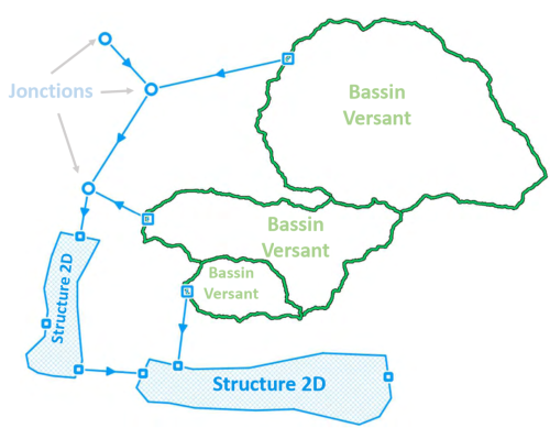
One or several models in a hydraulic network
The integration of a 2D model, called “2D structure” in Lekan, can be done either by building the complete model within Lekan or by importing a previously externally constructed model.
The user can then connect all 2D structures to watershed outlets, junctions, hydrograph sources imported from a file, from a remote server, or entered directly into Lekan, or even connect different 2D structures to each other.
These connections are made using hydrograph transfer methods that have existed since version 2.2, allowing for the inclusion of flows from different sources or other models into the model and the retrieval of output flows for injection elsewhere.
Model creation
For models constructed in Lekan, the user can:
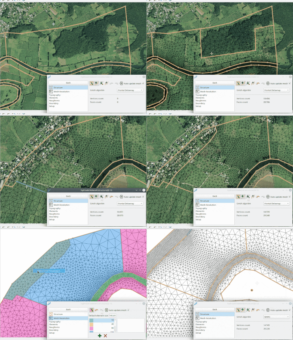
- Enter the domain and structure lines
- Define polygons associated with a mesh resolution
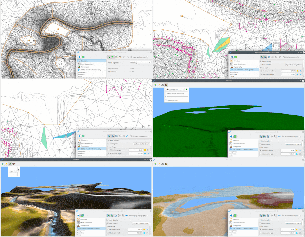
- Generate a triangular mesh using several algorithms (GMSH)
- Apply one or more topographies on the mesh from raster DEMs
- Define polygons associated with roughness values
- Add/remove boundary conditions (flow rate, water level) that can be connected to other elements of the hydraulic network of the project.
Simulation parameters (time step, initial conditions, numerical schemes, and other options) are defined before launching the model without leaving Lekan.
With this version 2.3, the supported solver for models constructed in Lekan is TELEMAC 2D.
Model import
Importing models is done by selecting the file describing the model. The model is then integrated into the current Lekan project. The boundary conditions can then be connected to the rest of the hydraulic network of the project.
With this version 2.3, HEC-RAS models can be imported. For each HEC-RAS “plan”, a hydraulic scheme can be created, thus allowing several HEC-RAS model scenarios with different boundary conditions and/or geometries for each Lekan hydraulic scheme. The user can modify the temporal parameters as well as the boundary conditions in terms of flow rates and water levels, and/or connect them to the rest of the network. Starting the model resolution can then be done without leaving Lekan, provided that a version of HEC-RAS compatible with the model is properly installed on the computer.
Visualizations and analysis of results
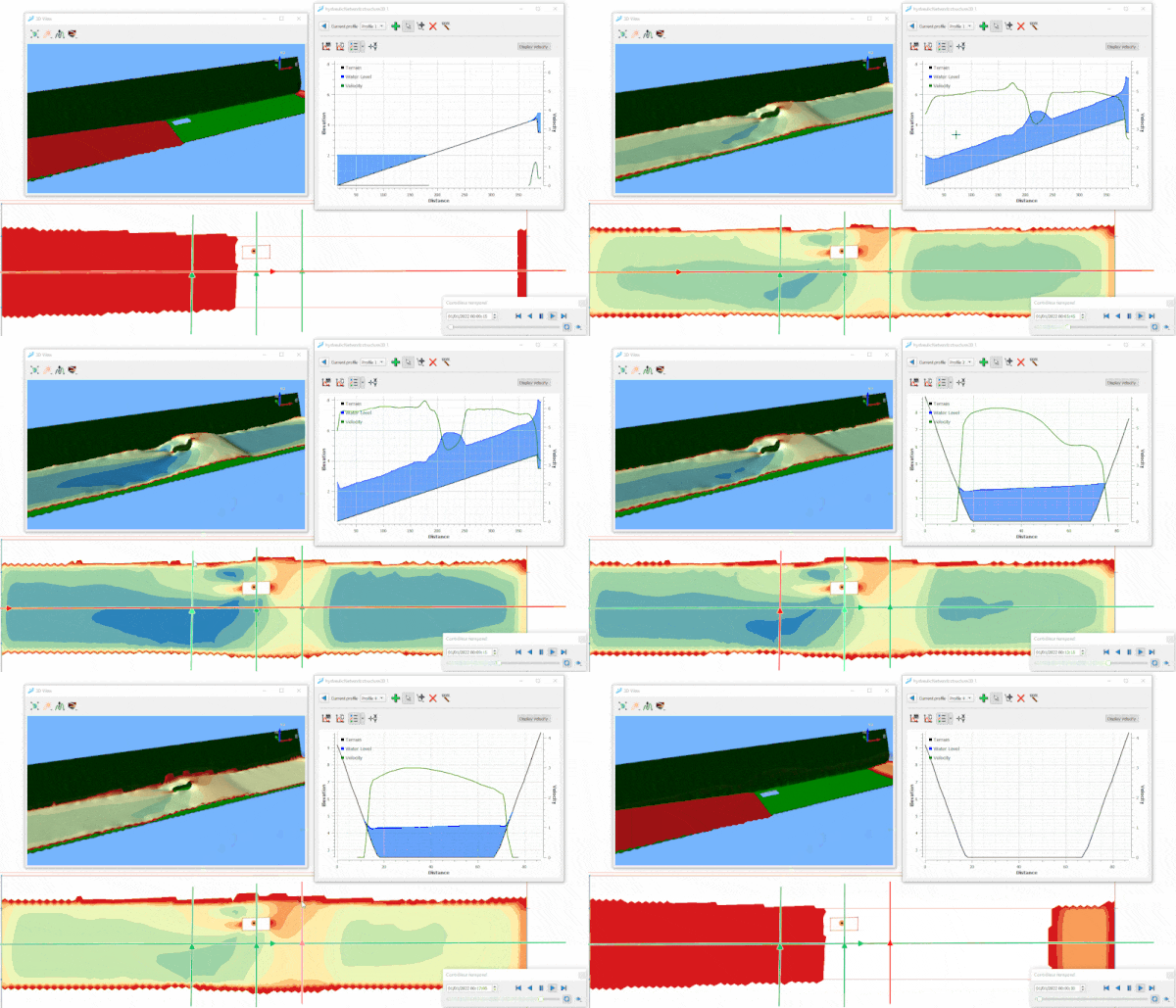
Once the models created or imported into Lekan are solved, the results can be visualized:
- In plan on Lekan’s map canvas: water levels, water heights, flow velocities are displayed using customizable color ramp, and flow velocities can be visualized as vectors, streamlines, or static or dynamic traces.
- Longitudinal and transverse profiles can be defined by the user to visualize water levels and flow velocities in section.
- A 3D view allows for a better visualization with the free surface of the flow and the terrain relief.
Note that it is possible to export the results via a QGIS project file. This project contains the GIS layers present in Lekan as well as a mesh layer that will contain the modeling results with the same formatting as in Lekan. This export allows for the creation of beautiful result maps with a tool that is much more suited to cartography, but still free and open-source!
Extension to other solvers
While the supported model types remain limited today, both for creation and importation, the infrastructure has been designed to integrate other solvers. The objective is to extend the possibilities of creation or importation to other models, allowing Lekan’s interoperability capacity to be expanded. Depending on the specificities of other solvers that will be integrated, Lekan will extend its functionalities in a generic way to adapt to the needs of the models.
Spatialized precipitation
This is the other major new feature that comes with version 2.3. Spatialized rainfall is precipitation data distributed on a matrix grid where each pixel has a variable precipitation value over time. Spatialized rainfall data can come from radar or weather forecasting models.
In Lekan 2.3, it is possible to import spatialized rainfall data from the “rainfall manager”. Several formats are currently supported:
- generic GRIB2 format, the user must specify the variable to use in the file
- COMEPHORE, Météo France radar data at hourly time steps, TIF or GRIB2 files
- HEC-DSS, format of the U.S. Army Corps of Engineers’ Hydrologic Engineering, also supported by the famous HEC-HMS and HEC-RAS
- remote AROME database from Météo-France, the latest hourly rainfall forecasts for the entire France and the Overseas departments and territories.
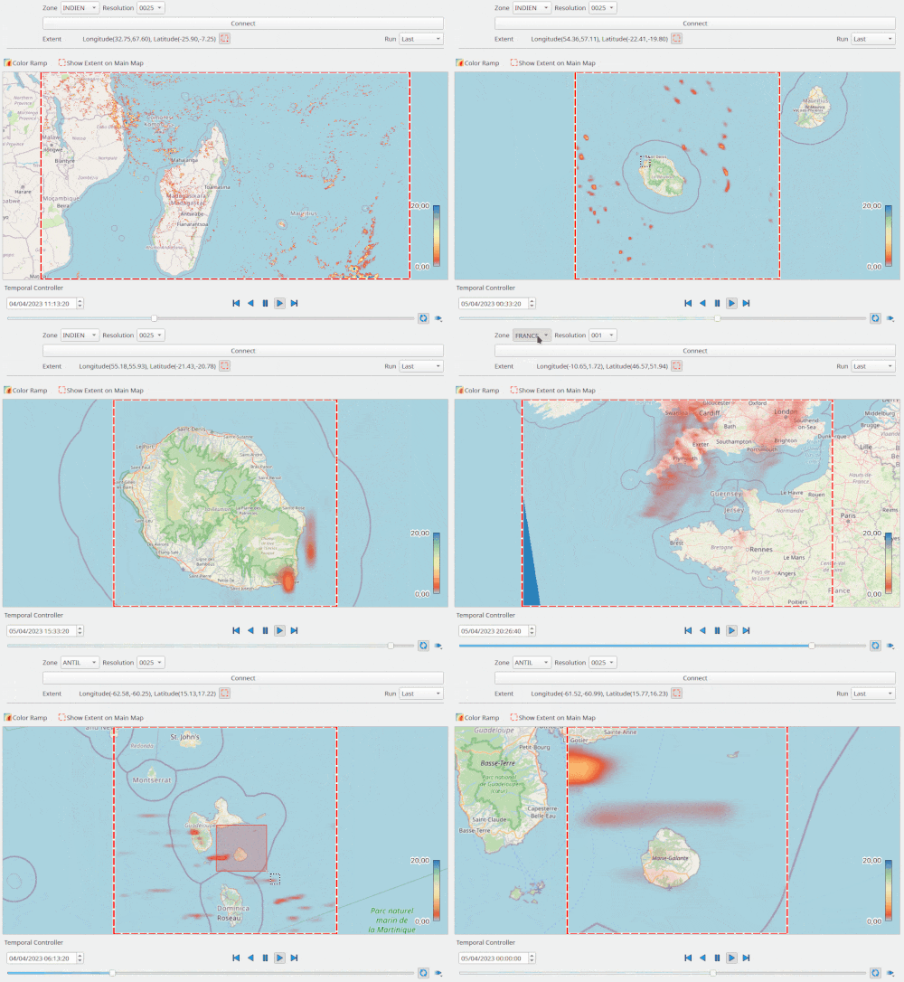
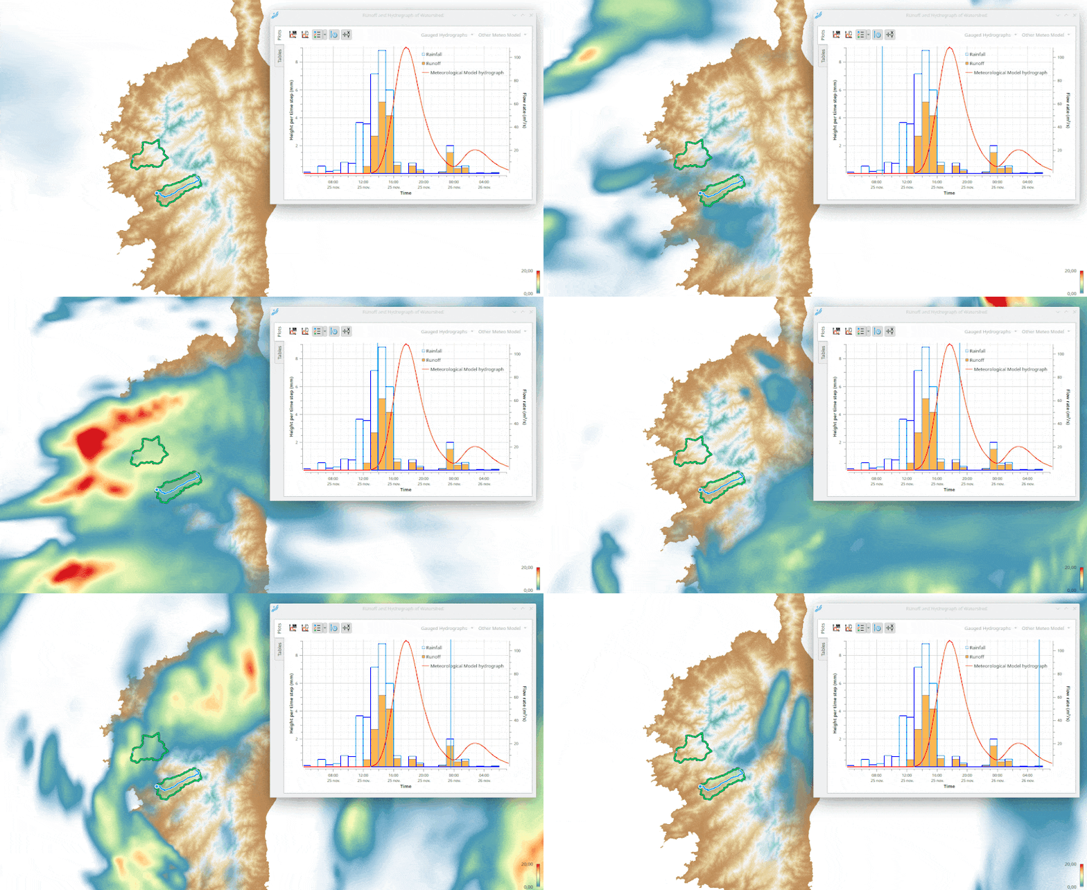
Regarding meteorological models, these spatialized rains can then be associated with a watershed to generate a hyetograph or with a 2D model accepting this data as input.
For version 2.3, only HEC-RAS models accept spatialized rainfall as input; this option has not been implemented for TELEMAC 2D, even though this solver accepts this type of input. This may be the case in the future.
Other improvements
This new version was also an opportunity to fix some issues and bugs. Version 2.3 thus offers much better stability for the features already present in previous versions.
Several minor features have also been added, such as the import of watershed delineating from a vector layer, the ability to export the desired watershed delineating, a list of recent projects to open, …
And now?
This new version required some effort, especially in terms of time. This version remains free to use and its code is open source. If you appreciate this version, don’t hesitate to contribute to this effort, through translation, help with documentation, spreading the word, or even financial support which would be greatly appreciated!
While this version brings many new features, it is only a glimpse of the imaginable possibilities of interoperability and associated calculations. Indeed, it may be possible to extend the functionality to the integration of other hydrological methods or models based on other data such as land use, vegetation cover, and even experiment with the trendy ‘Deep Learning’ for the estimation or prediction of flood hydrographs.
On the hydraulics side, supporting point clouds (LIDAR), integrating other solvers, adding functionality tailored to their specificity, and better leveraging the results of solvers currently available will only expand the range of modeling possibilities and improve the user experience.
Moving forward, development around Lekan is now focused on a server version and also on the development of a Python API allowing for more advanced uses, such as automating data retrieval, parameterization, and hydrological/hydraulic model solving through scripts.
The idea is to enable the implementation of autonomous, customizable, and controllable systems, for example, for flood forecasting, automated data processing over time, and so on.
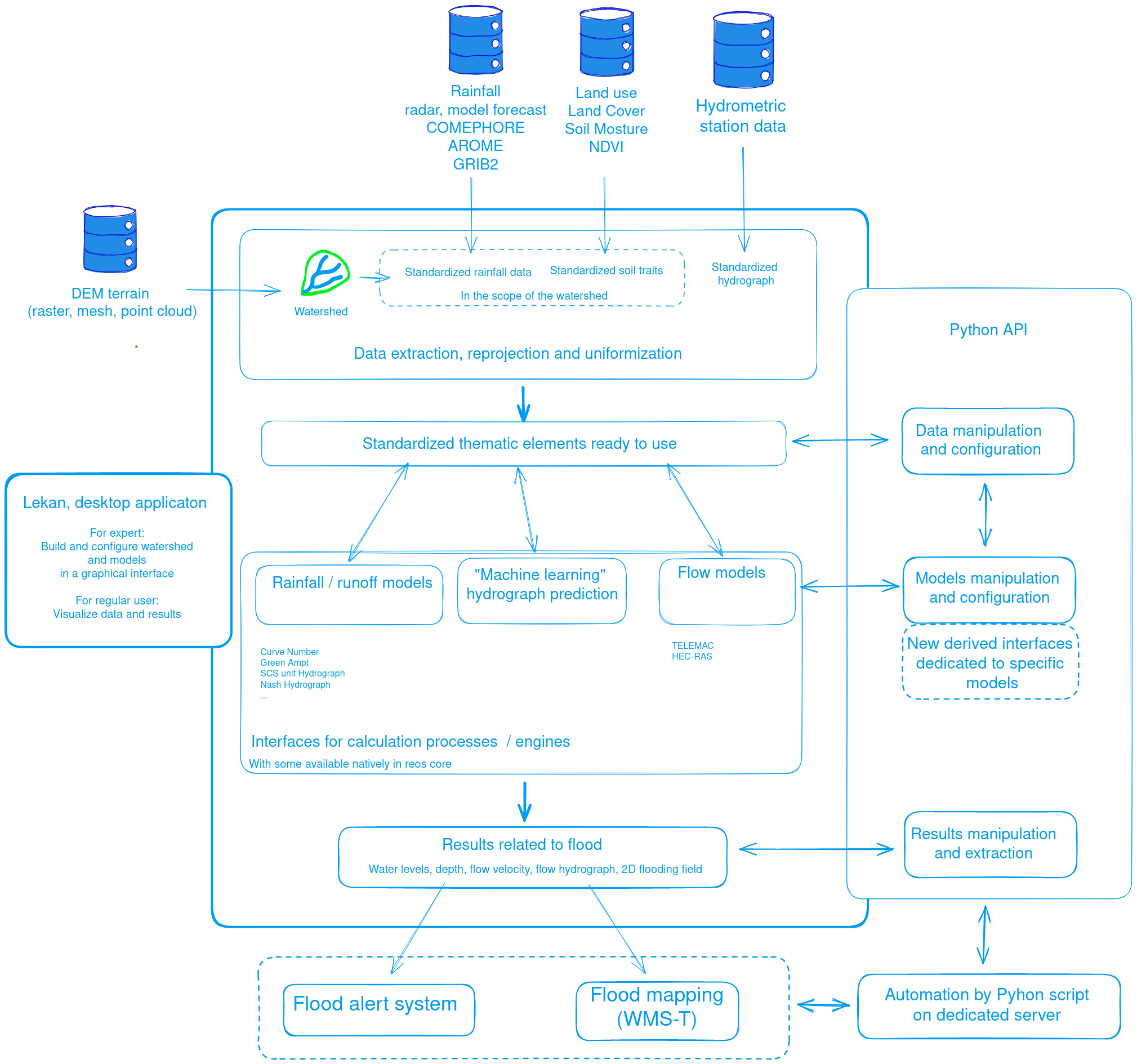
The diagram below represents the organization on which such a system could be based.
As input, the system accesses databases of digital elevation models (DEM), rainfall data, land use, hydrometry, and so on…
The extraction and standardization of this data will then allow processing by different hydrological or hydraulic models/processes. Note that an interface could allow for the integration of external processes, whether they are open source or proprietary.
There is no shortage of development ideas, so if one or more themes are of interest to you in your activity, please contact me ( ) to find out how we can prioritize and accelerate this development together.

Leave A Comment